Thursday, July 26, 2012

Day 86

We left Thunder Bay half-way through the day and started to see Lake Superior, and some of the great scenery we were going to start experiencing. We managed to bike 60 km just past the town of Pass Lake, in a picnic area.

We woke up to heavy downpours, some of the worst we had seen on the trip so far. We biked 60 km straight to Nipigon for lunch at "the office". The rain was coming down hard enough that it actually started to sting. We took a 4 hour break in the town, loaded up on groceries and managed to bike another 50 km towards the town of Rossport. We set up our tent on the side of Highway 17, and the rain was starting to die down. The hills were starting to get a lot bigger again though.

not pictured: massive hills all around us

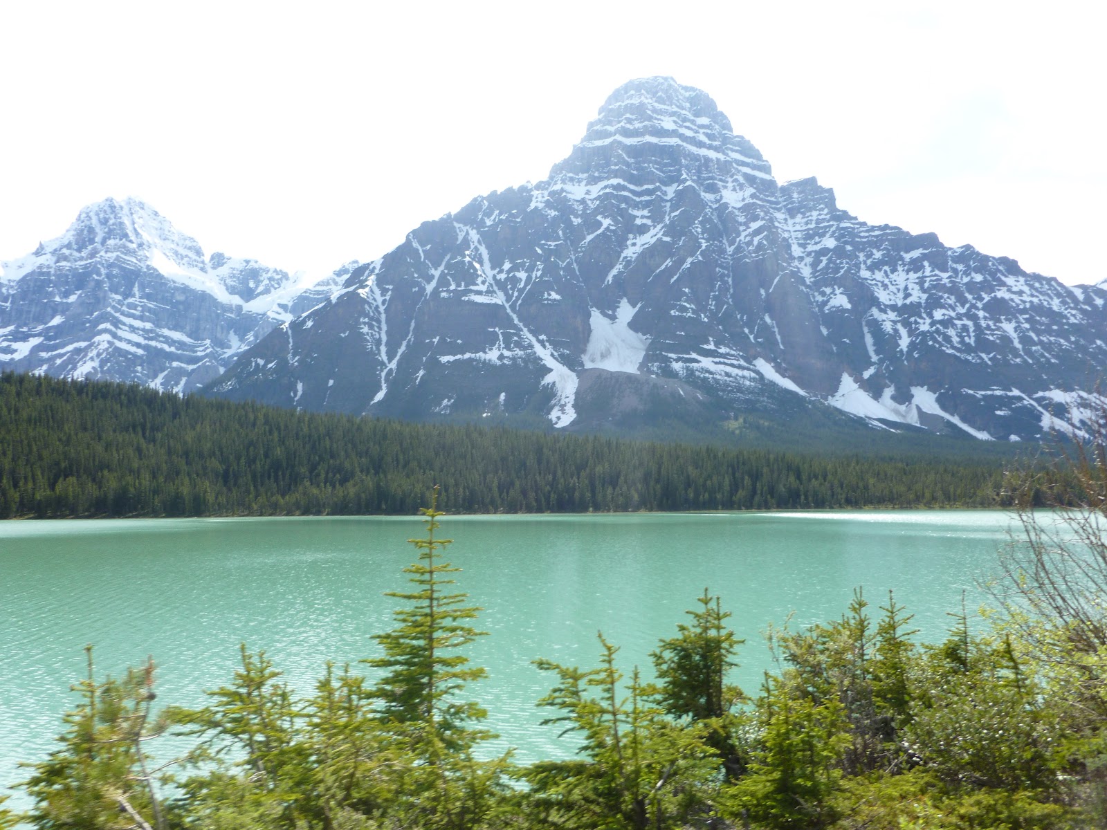
The hills along the North shore were pretty rough, not as bad as BC, but still tough. We also had headwinds ever since we left the prairies. We met a guy who was walking across Canada with a loaded cart of bags and water. He was just doing it for fun and couldn't speak any English. He was Japanese, and luckily Will is fluent in speaking two words of Japanese: konichiwa and arigato, so after repeating those words for several minutes we parted ways with our new best friend and kept riding along. We stopped for lunch in Terrace Bay, where we had a great view of Lake Superior again. We finished the day camping behind a gas station at the turnoff for Marathon.

 
"I swear I can throw this rock to the other side"

The next day we had a very late start because Will lost his phone charger and had to bike the 4 km into the town of Marathon. We still managed to get 130 km done by the end of the day. Had lunch in the middle of nowhere at a truck stop. We also saw a statue dedicated to Winnie the Pooh when we stopped in White River. It was where the black bear who inspired the children's books was originally purchased. We camped on a dirt road, not next to it, on it.

near lake Super-Eeyore


By this time we wanted to make it to Sault Ste Marie in two days, and we still had 280 km to go. With the hills we were facing, it was going to be a challenge. We stopped for lunch in Wawa,  a town famous for having two very large statues of geese, one named Wa and the other named Wa as well, probably. The weather was still really favorable, so we managed to bike 142 km by the end of the day. We set up our tent across the street from the campground. Before we finally set up our campsite, Will passed Harry without realizing it. Will kept on biking and biking because he thought Harry was still ahead of him. Finally, he took a break and Harry caught up to him, but it was the main reason we managed 142 km.

Cuisine chez "this is definitely illegal to have a camp fire on the road"

Luckily the conditions were still great to make it to the Soo by the end of the day. Our biker friends that we met in Clarenville, Newfoundland (Kibby and Daman, the people we did the Maclean's interview with) were already in Sault Ste Marie and we had planned on meeting them at a local bike shop. The bike shop Velorution has a spot behind their store where they allow touring bikers to camp for free. When we arrived, we were delighted to find that Kibby and Daman were there, along with about 6 other bike tourers. We had a great time catching up, sharing stories, and just having a great time with people who shared our interests.

dank

We took another half day off in the city. We bought groceries, fixed up our bikes, and watched the new Batman movie, and then we were on our way. We didn't leave until about 7:00 pm so we only managed to get in about 45km, but it was still better than nothing. Again we set up our tent behind a gas station, because we wanted to go to it in the morning.

After we had our breakfast and coffees at the gas station we were off on our home stretch towards Aurora. We stopped in Thessalon for an all-you-can-eat brunch, which was amazing. Another 100 km after that we stopped for the day in a small town called Spanish. We camped behind an abandoned bowling alley. We kept being woken up in the middle on the night by transport trucks, whose driver's apparently never sleep.

We took a short break in the town of Blind River, where we recorded the video which may seem to have nothing to do with biking across Canada, but it actually has everything to do with it, somehow.
http://www.youtube.com/watch?v=r66vLXqNVQg

The next day was our earliest start, 8:45, because we thought there may be a possibility to catch the 10:00 pm ferry by the end of the day. It was going to take some hard work and luck, because we would have to bike a personal best of 160 km. We took our lunch break in Espanola at the office. After that we turned south of Highway 6 towards Manitoulin Island. The hills got a little bigger right before we hit the island and we also had to deal with some very strong winds. However, we persevered and managed to hit our mark of 160 km by 8:00. We arrived in Tobermory at 11:30 where we camped beside a baseball field.

Office Supplies

Here is a video of what life was like living in a tent for 3 months: http://www.youtube.com/watch?v=uvA3NtnsaYg&feature=youtu.be

From Tobermory we just dug deep and cycled, 140 kms each for two days, and ended up in Aurora to finish our trip on the 25th of July, Harry's birthday. In total we biked 8030 kilometers in 86 days. We're really happy to accomplish this, and we're ecstatic about how much money has been raised for the First Nations Child and Family Caring Society. Thank you so much for reading the blog. Take care!

Sunday, July 15, 2012

Day 76

The Day 69 blog post we finished in Winnipeg was apparently lost. We can't say we're surprised that it's been lost, we suspected for some time that it was too good of a blog post to be true. Things happened between Regina and Winnipeg, but not much. Unfortunately we can't hook Harrison's camera up to the computer, so we wont be able to add many photos, but here are a few videos that we took between Regina and Winnipeg:
Camping in Wolseley, Saskatchewan: http://www.youtube.com/watch?v=e1aMRZeexO8&feature=plcp
Being stealth in Portage la Prairie, Manitoba: http://www.youtube.com/watch?v=5Wz7LoAgCvk&feature=plcp

We biked about 5 km outside of Winnipeg, instead of spending a second night there, because it was easier to find a place to camp. When we got to biking the next morning the road was still very flat, but we were fast approaching Ontario which we knew would have a ton of hills. We managed to bike close to 150 km on our last full day in Manitoba. We set up our tent in Caddy Lake in the Whiteshell Provincial Park. The road into the Caddy Lake campground had the first legitimate hills we've seen in a long time. Additionally, we were now surrounded by forest instead of the prairies. Here is a video of where we camped and some of the other campers there http://www.youtube.com/watch?v=sxTpE_eCqqw&feature=plcp.

We also rode through the town of Rennie, a remarkably unremarkable town.

And they know it.

When we left the next morning we made a quick stop in West Hawk Lake, a small cottage town about 5 km from the Ontario border. When we finally crossed into our home province we were both excited to be on the home stretch, even though we had 2000 km to go. The change of scenery that came with entering Ontario was nice. There were now trees and lakes everywhere. We stopped for some lunch in Kenora, and stocked up on supplies knowing that our next stretch may be the most barren part of the trip. We managed to bike another 60 km to Sioux Narrows where we stayed the night at a local park. The dense forests and lakes, combined with very few towns results in seeing a lot more wildlife. In the last 4 km of the day we saw 5 deer.

We biked the 20km into Fort Frances where we had some breakfast and took advantage of some free WiFi at the McDonald's. When we finally left the town of Fort Frances the road became very barren. We biked another 115 kilometers that day and the only sign of civilization we saw was a gas station 10 km from Fort Frances and another gas station that went out of business. The major issue that this brought was running out of water, which would happen multiple times on this stretch. There were no taps of fresh drinking water, and the temperature was well above 30 Celsius. We each finished our 5 bottles before we wanted to stop biking for the day. Luckily a nice lady, who was escorting another biker going across Canada, filled up a bottle each for us. This got us to where we decided to camp for the night. We set up our tent beside a lake where we were able to get water, and Pristine it. When we were setting up our tent, there was a flash thunderstorm with very heavy rain for about 15 minutes. These flash thunderstorms have become a common occurrence over the past week. There was also a tiny frog that lived near where we were camping, but it must have been the laziest frog in the world because we were absolutely swarmed by mosquitoes and the frog just sat there and watched.

This is where we camped, minutes before thunder and mosquitoes decided they would be spending the night  there too.

The next morning we found a town, Atikokan, which was about 5 km off of the highway we were taking. It was worth the detour, as we were able to stock up again on groceries and fresh water. The road again proved to be very barren and the weather to be very draining. We saw a gas station and restaurant where we stopped for some lunch. A few flash thunderstorms later and we made it to the ghost town of Kashabowie.  Needless to say, we were excited to get to Thunder Bay the following day.

The ride into Thunder Bay may have been the hottest and sweatiest ride of the whole trip, but we dug deep and persevered. In Thunder Bay, we decided to stay at the Lakehead University residence for the night, but Will got lost somewhere on campus and needed to ask someone for directions. Lakehead was pretty deserted because it was a Saturday and it was the summer, but Will managed to find someone to ask for directions, but as he pulled up to the guy they realized they knew each other. It was Uko, a friend from Will's bowl-cut elementary school days. After catching up for a bit and marveling at the crazy improbability of having run into each other, Uko mentioned that he was hosting a radio show at the campus radio station that evening, and we decided to make it the best radio show ever by talking about our trip.

"...and then we kept pedaling..."

Thunder Bay is a nice city, but the most interesting thing about Thunder Bay is how it got its name. In 1969 the towns of Fort William and Port Arthur decided to become one, and a referendum was held to determine the name.There were three options that made it on to the ballet: Thunder Bay, Lakehead, and The Lakehead. "The Lakehead" took in just over 8,000 votes, "Lakehead" got 15,302 votes, and "Thunder Bay" got 15,870 votes. More than half of the people wanted some variation of the name Lakehead, yet because they couldn't agree on whether to throw in an article, the vote was split and Thunder Bay took the cake. Wow. The lesson? Just wow.  

Monday, July 2, 2012

Day 63

We weren't able to upload the pics Harry took, so we'll edit this later and add those in.

We left Calgary having changed our chains for the second time. After a few of the kinks were worked out (by 1:00 pm) we were finally biking on the plains of Alberta, heading towards Saskatchewan. It was still raining very hard, but we had a tail wind so we were happy. By the end of the day we managed to bike 105km in only 5 hours on the road, finishing in Bassano behind a shed. We were already starting to notice how few trees and fences there were to camp behind and knew that we would have to kick our stealth camping up a notch in the prairies.

Once we left Bassano the rain had finally stopped and the wind was still at our backs. It was a really good feeling to have flat roads, sunshine, and a tailwind. We took advantage of the amazing conditions and managed to bike 155 km to Medicine Hat. Along the way Harry lost another wager and had to ride the rest of the way into Medicine Hat, and order dinner, with a straw cowboy hat on with a long piece of grass in his mouth. For dinner we decided to hit a local steakhouse for some premium AAA Alberta beef. Medicine Hat is one of the largest cities we had stopped in, so it was quite difficult to find a camping spot. Here is a video of where we finally set up the tent  http://www.youtube.com/watch?v=98C-hpJHoGY&feature=youtu.be.


Fitting in with the crowd

After leaving the Hat we were only about 50km from the Saskatchewan border. We were biking just north of the Cypress Hills Inter provincial Park, so we actually had to bike through some of the foothills of Saskatchewan. Contrary to popular belief, Sask is not entirely flat. It is also not as barren (in terms of gas stations, restaurants, and small towns) as Newfoundland was. We saw a group of three girls biking across Canada, but they were cheating because they had an RV carrying their bags. The riding was still easy-going and we managed to pedal about 100 km past the border, finishing at a camp site in Tompkins. It was day 59 and for the first time we were camping in a legitimate camp-ground. We met a married couple biking East across Canada as well, so we exchanged tips and tricks and now were best friends forever.

We left our camp bright and early for another day on the prairies. We stopped in Swift Current for lunch, the office (Tim Hortons), and a bike shop. We finished at another camp site in Herbert where we ran into some furry friends  http://www.youtube.com/watch?v=bRO54hJW7Qc&feature=youtu.be. We had actually had our camp set up next to these guys for over three hours before we realised they were there. They are extremely quiet animals. Too quiet. We slept with one eye open that night because we were certain they were plotting something. Sure enough, when packing our tent up two mornings later one of the rods kind of broke a bit. We don't know how they did it, but we know for sure it was them.


Who else could it have been?

When we woke up we wanted to grab some breakfast at the local family restaurant, or the cafe, in Herbert. Both were out of business, so we went 13 km down the road to the next town, Morse. When we arrived the gas station and grocery store were opening at 8:30, but it was 9:00 and they still weren't open. After coming to the conclusion that Saskatchewan as a whole is lazy, we realised that the problem was that we mistakenly set our clocks forward an hour when we crossed the Saskatchewan border. Apparently Saskatchewan doesn't believe in Daylight Savings Time, so half the year its clocks are in-synch with Manitoba, the other half they're in-synch with Alberta. Our suspicion was confirmed, Saskatchewan really is lazy. So after unsuccessfully trying for a bit to convince all of the Saskatchewinians to just not be that way, we decided to just let it go and move on. Later, Will successfully ran over a large staple with unbelievable precision so he popped another inner tube, however, as we are now professionals at changing them it was not an issue, and some experts are saying he may have even set a new world record for fastest inner-tube replacement ever. We set up our tent at another camp site in Moose Jaw.


Picture of a four letter word starting with "s"

From Bassano to Regina we needed to bike 610km and we had 5 days to do it to arrive on Canada Day. When Canada day came we had biked 540 of those kilometres, so we expected the 70 that remained to be a breeze. Unfortunately, the tailwind which we had been riding for most of the week turned against us. The wind in the prairies is devastating if you have to bike into it. With the tailwind we were averaging 25 km/h, with the headwind we averaged 15 km/h. We managed to arrive in Regina by 4:00 where we had made reservations for a room at a hostel. We proceeded to celebrate the birth of Canada.


Monday, June 25, 2012

Day 56

Video from last week's blog post, camping outside Cache Creek: http://www.youtube.com/watch?v=xQ_QWakS9bA&feature=youtu.be
This video depicts the arid landscape around Kamloops.

We left Sarah's place in Kamloops and headed towards Jasper National Park over the next week. We started to notice that the vegetation again changed from the arid hills of Kamloops to the dense vegetation and snow tops of the Rocky Mountains. Anytime we have a packed lunch we manage to bike an abnormal amount of kilometers, and again this was the case as we biked 130km and finished in Clearwater.

After camping in the backyard of a motel in Clearwater we woke up to torrential downpours. We hid out in a cafe for around an hour, however, it didn't help in the long run as we were soaked by the end of the day. We managed to bike 109 km over 8 hours on just protein bars and apples, so we were happy to reach our destination of Blue River and have some dinner. We set up camp behind the restaurant where Will managed to kill close to 6000 mosquitoes double-handedly.

Our first black bear sighting
We left our campsite and it was still raining, but luckily we managed to miss the forecast of thunderstorms. The hills were starting to get larger as we got closer to Jasper, but they were still quite manageable. We also had our first major wildlife encounter, as there was a black bear on the side of the road. As the day went on, the rain was on and off, so we decided to have lunch under a bridge.
Here's a video demonstrating "how we do": http://www.youtube.com/watch?v=rErs-i37sMg&feature=youtu.be 

We made it the town of Valemount which was surrounded by mountains and may be considered one of the most scenic towns that we've come across. When we had finished buying some groceries a man by the name of Dave donated $60 to our cause and also gave us a jar of homemade raspberry jam. Afterwards we managed to bike another 15 km before the headwind became too much and we camped in the Jackson Flats Provincial Park.

Harry rocking short-shorts in Valemount. He lost a bet.

We had one more day of biking before we reached Jasper National Park and the city of Jasper. The mountains were becoming larger both in size and in number. Mount Robson, the highest peak in the Canadian Rockies at 3940m, and Mount Terry Fox at 2680m were some of the more notable ones. We were a little disappointed though because, as it was raining again, there were clouds covering most of the peaks. About 10 km into the day we entered Mount Robson Provincial Park, which not only offered great scenery, but clear blue rivers formed from glacier water. Legends say that it's not in fact water, but blue Gatorade, or maybe even Blue Gatorade powder in liquid form. When we passed the Alberta border and into Jasper National Park the scenery was even more spectacular and a sign of great things to come.
 
 Alberta. You're welcome.


Great things are coming

As we left Jasper we had to pass another gate to enter the National Park...again. However, before we even passed the gate we saw a herd of caribou (which we took the liberty of pronouncing "elk") and you can see the video here (http://www.youtube.com/watch?v=TaTrfUkc22Q&feature=youtu.be), and we also saw two coyotes hiding in the bush.

Once we passed the gate we saw two more black bears. So in the span of under 5 km we saw three different large mammals. Further down the road Will also spotted a very large caribou and two wolves. We thought we were about to witness a show-down of epic proportions, but the wolves chickened out. Harry also had the privilege of spending some time alone with a black bear at the side of the road, for about 5 minutes before all the crazy tourists showed up and scared it away.

"Hey Harry"
The day consisted of very long and steep climbs, with very few downhills. We also had our first flat tire, Harry's rear tire was completely deflated by a piece of glass at the top of a large hill. We managed to repair the damage without a hitch. But then, we came face-to-face with a mysterious and majestic animal known by many as a mountain goat. We decided to use a more authentic pronunciation of goat in the video though:
http://youtu.be/B8GDgzXPmOw

By day's end we were at an altitude of close to 2000m at  the Columbia Icefields Info Center. We set up camp less than a kilometer from one of the largest glaciers in the Rock Mountains, so it was a little chilly.


We left the Icefields in the morning for another day of long hills. However, we were surprised to find that we also had about 20km of straight downhill in the morning. We did 20km in probably 30 minutes, a new world record. The Icefields parkway was scattered with gigantic mountains and clear blue lakes, the scenery is unbelievable. We finished the day passing Bow's summit, which marked the highest altitude for the entire trip. Our legs were tired but knowing that it was going to be downhill for the rest of the day made it easier. We camped just outside Mosquito Creek campground, about 25km from Lake Louise.

Just after biking 20km in 30 minutes, not even tired. 

Just a taste of the two days that we were on the Icefields Parkway 

Our next destination was Banff, which would be a much flatter route but would prove to be difficult in other ways. One particular difficulty involved The first wipe-out of the trip, as Will flew over his handlesbars along the shoulder of the Trans Canada Highway. Harry caught-up with Will about an hour later, and we've decided to include the conversation we had in this blog, verbatim:

Harry: hey
Will: Hey, I wiped out.
H: what happened?
W: So there I was, minding my business, biking along, and then a road sign appeared on the shoulder, out of nowhere! So I swiftly swirved to the right and dodged the sign perfectly. But turned out that the fresh pavement on the shoulder was way too loose so my front tire turned 90 degrees. I went about 3 or 4 feet forward, but my bike didn't. I got my hands up pretty quick and capped off my landing with a forward roll, so i'm alright.
H: did anyone pull over to see if you were alright?
W: Nope. But I don't blame them. Do you ever stop what you're doing when you see a butterfly flutter and with a determined elegance land on a branch? No. And similarly, people didn't stop for me because I looked like a pro. One van even had a passenger judge my landing, and gave me a 9.5 on a scale of 1 to 9.5, presumably.

photograph taken by Anonymous

Will got right back up and kept trekking, but within a few kilometers his rear tire decided it couldn't handle being a part of such a legendary bike ride, so the inner tube popped. No problem though, Will had an extra inner tube in his bag so he just replaced it and went on his merry way. But the tire was relentless in it's effort to throw in the towel, so the brand new inner tube popped within 2 kilometers. 
Will giving a stern talking-to to his tire.

It's important to note that none of these hardships were caused by human error. Obviously. We then realized that the tire was in such bad shape that we wouldn't be able to make it to Banff. So we hitched a ride on a coach bus and made it to a bike store in Banff, where we proceeded to buy brand new tires that promise to never wear out on us.

We then spent the night in Canmore, and the next day we made our way to Calgary, thereby ending our run in the Rock Mountains. After having biked a stretch of 13 straight days and 1200 kms, we decided to take two days off at Harrison's Grandfather's place just outside of Calgary. Thank you to Roy and Jan for their hospitality.

NB: One of the highlights from our time in BC was when we stopped in a restaurant in Lytton and had a great conversation with the owner. She was a very talkative woman. One of her stories that she shared was about her then 5 month-old son who was terminally ill. Her son managed to survive and is doing very well now, 15 years later, but her story very much struck a chord with us. She told us that when it was determined that he was terminally ill, a government program made it so that she would be able to take him back home to her small town, so that he could spend his last days with his family, rather than in a hospital in the big city hours away from his family. She told us one of the most disturbing things for her, at the time, was that the government, which was allowing her to take her son back home by offering to cover the exepenses for all the necessary medical supplies, made her take four years of supplies at minimum. She, as well as the doctors, knew that she would only need one year's worth of supplies, but there was no way around it. The supplies had to be given to her, and she knew that this meant that they were going to be wasted. She did manage to give some of the supplies that didn't have expiry dates to the local doctor, but she felt bad that so many supplies had been needlessly wasted. In her own words, she told us that the supplies could have been used to help three other families, but that her hands were tied by the very program that was trying to help her. The reason why this struck a chord with us is because of how closely related it is to the cause that we have chosen to support. Among other things, including improving educational programs and social programs for on reserve aboriginal children, the First Nations Child and Family Caring Society is actively involved in legislating something called "Jordan's principle". The program that allowed this woman that we met to take her son home for his last few days or months is a program that does not apply to on-reserve aboriginals, because neither the provincial nor federal government is willing to front the bill. All this while simultaneously affording an over-abundance of supplies to people that don't need them. You can read more about Jordan's principle, which aims to put an end to this discriminatory procedure, here. This was a great reminder for us about the cause behind our trip, and a great opportunity for us to extend our thanks to everyone who has donated to the cause and helped in any way. Thank you.


Friday, June 15, 2012

Day 46

We left Vancouver towards Mission for a night of rest and relaxation at Beth and Greg's place (Harrison's aunt and uncle). The route was relatively flat, but we got to see the beginnings of the Rocky Mountains. It gave us a glimpse of the amazing scenery to come. When we arrived in Mission we were greeted by Beth, Greg and Lindsay and had a great streak dinner. That night we caught the final game of the Stanley Cup which was a nice treat.
When we left Mission we were excited to start biking into the Rockies, and we after much deliberation and consulting countless experts and after doing science, we made the decision to take the Fraser Canyon (Highway 1) as opposed to the Coquihalla (Highway 5). The Frasier Canyon had fewer summits and better scenery but 70 extra kms. When we arrived in the town of Yale we were assured that we made the right decision as the view was unbelievable. We biked another 15 km and set up our tent near what appeared to be an abandoned house. About 2 hours after setting up our tent the owner of the house came by with a report of someone on his property. He was a nice guy though and didn't mind us camping on his property.

Check out the scenic Fraser Canyon River:  http://www.youtube.com/watch?v=4sycwQ1oztc&feature=youtu.be


The road along the canyon has a few tunnels. Cool!


After we left our campsite we started to get a taste of the mountains that were to come. We had a few 2-3 km hills, but nothing too major. We also had the wind at our back which was a huge help for the first day of serious hills. We met our first serious BC hill, one that many had warned us about, and we met it with ease because we happened to have heavy winds at our back. Here we are after accomplishing that first big hill: http://www.youtube.com/watch?v=Uc3NIqxel68&feature=plcp.
Unfortunately the camera was turned off right before we were presented with the most prestigious award ever, in front of everyone, for biking up that hill.We graciously turned the award down though, because we're not done yet, and will bike up atleast one other hill as we cross the Rockies.


 Not a word of a lie. This is the name of the hill we biked. Pretty harsh.

That night we camped just outside of Spence's Bridge.

When we left our campsite we had about 1 bottle of water each knowing that in Spence's Bridge we would be able to fill them up. However, when we arrived every single shop/cafe/motel was out of business. Our next stop was about 50 km away and so we had to stretch the one bottle each for around 3 hours of biking. We managed, mostly because the sun went away and it started to rain. The rain wasn't terrible and after a quick stop in Cache Creek we set up camp close to Savona. Video of the campsite to be added later.


 Harry biked right by this gem-like scenery without even stopping to look at it. Thankfully Will is better than Harry at some things.

The last video depicts one of the more interesting aspects of our trek along the Fraser Canyon, the vegetation changes drastically, and the change is not subtle at all. it goes from a lush green rainforesty vegetation and climate to a more arid and desert-like setting. It's really a quick transition, and we've been told it changes back shortly after Kamloops.


Just can't get that timer function on the camera right

The next day we arrived in Kamloops. With pretty harsh head-winds, we were reminded just how difficult the hills can be when the wind doesn't go our way. But it was a sunny day and a relatively short day distance-whise so we would be able to arrive in Kamloops without too much of a problem. We also met 4 other cyclists that were touring across Canada. Cool. They were Swiss. Interesting.

Up next we head north to Jasper so that we can take the road along the Columbia Icefields from Jasper through Lake Louise to Banff. We could cut through from Kamloops to Lake Louise, but we think the detour up to Jasper will be worth it. We're pretty excited for it. Thank you again to Sarah and Josh for the amazing hospitality, a welcome change from the camping over the past 3 nights!

Sunday, June 10, 2012

Day 41

The morning of May 28th we were lucky enough to be interviewed by the local radio station at Cheticamp, but that meant that we didn't start biking until around 12. That morning we had also decided to change our chains because we had already biked about 2200 kms. Right when we started biking Will's chain started to skip and so we spent 30 minutes fixing it which put us further behind schedule. 2 km down the road Harry's chain started to skip and Will's snapped in half. Excitement ensued. We didn't have any backup chains at this point because we had just used them, so we took the good old trial and error approach and actually managed to patch things up and travel 30 or so kilometers. However, at that point our chains decided to start skipping again and we had no option but to keep trialing and erring, but mostly erring. Eventually we decided that it was hopeless, and that we would need to get a new chain, but we were in the middle of Cape Breton, and the nearest town with a store that would sell bicycle chains was over a hundred kilometers away. That misfortune actually proved fortunate. People in Cape Breton are some of the kindest people you'll meet, and we actually managed to hitch a ride all the way to North Sydney from Rob (lobster fisherman) and his fiancee, just beside the town that would have the store and chains we needed, as well as the port for the ferry to Newfoundland.

The next morning we stocked up on new chains, replaced our embarassing old ones, and hopped on the overnight ferry to Newfoundland. Will would turn 23 years old on that ferry, and slept a sound 4 hours on the floor before we set out to tackle all 900 kms of newfoundland in 9 days.


NL 

Here's a video of some of the scenery kilometers after leaving the ferry in Newfoundland, narrated by Will and guest starring the Trans-Canada Highway: http://www.youtube.com/watch?v=AvgGnhj-fd4&feature=youtu.be

The road from Port-aux-Basques to St. John's is just that, one road, and at points it is quite barren. We went the first 200 kilometers and saw more moosen (4) than we had seen stores (2 gas stations). Another interesting fact is that if you were to draw a line directly from Port-aux-Basques to St. John's it would head directly East. Our first two days in Newfoundland, however, had us going directly north, which of course meant that we would have to spend that much time to get back south enough.


The moosen built this fence so that we wouldn't bike on their turf

The trek to St. John's also featured some really cold and wet weather. We did not see the sun at all while in Newfoundland, and would wake up most days to puddles of water inside of our shoes. The first 30 or so kilometers would be the hardest. Our feet and hands would go numb from being so wet and so cold, but we would eventually warm up and would still manage to average just under 100 kms a day.


The sunniest moment of Newfoundland (it was behind a mountain)

We would still take some time to take in the scenery though, as shown in this video of scenic Gambo http://www.youtube.com/watch?v=bMLQgQrr9Jk&feature=youtu.be . Additionally, we had a day with excessive amounts of fog and it felt like we were on another planet, one with a lot of fog, but otherwise very similar to earth and specifically newfoundlandish. A very weird feeling indeed.


Breathtaking scenery

Newfoundland wasn't without its highlights though, as one day we ran into a couple of cyclists that had just started their trans-canada trek. Within minutes, a journalist for Maclean's spotted our bikes and took the opportunity to interview us about our journey. He's writing a book about the Trans Canada Highway, and his personal experience driving across it. We're not guaranteeing that we'll make it into the book, or on the front cover, but we've got a bit of a hunch that there's going to be an alternate book about just us, and a subsequent major motion picture. He is blogging for Maclean's almost daily, and he was sure to mention us. Here's a link: http://www2.macleans.ca/2012/06/05/day-2-on-the-trans-canada-gambo-nf/. Additionally, the two other cyclists have a blog at: www.trekking4transplants.ca 

One day, winds were in excess of 57 km per hour. This means that had it been near a school zone, the wind could have gotten a ticket for speeding and would be the recipient of many frowns from onlookers, not that either of us know what that's like, but we suspect the wind should be ashamed of itself for that. Nonetheless, we eventually made it to St john's and were lucky enough to camp in the backyard of Will's cousin Michelle's place while she was away in another part of Newfoundland. St. John's is a really nice city. From far it looks like its a really big town, but it has many of the same amenities you'd expect from a city, including a vibrant nightlife which we took the liberty of exploring. One street in particular, George street, is considered the street with the most amount of bars per square foot in all of either the world or North America, or Canada, or something. The point is there are a lot of bars that the newfies love to frequent and make the most of.

On June 9th, we packed our bikes up and flew to Vancouver. The flight, including a short layover in Toronto, took all of 10 hours. We covered the distance that is taking us 3 months by bike, in 10 hours by plane. We dont know what to make of that. When we arrived in Vancouver we were greeted by Brian and Audrey who welcomed us into their home. The showers, clean laundry, and home cooked meals were a welcome change from the cold tent-life in Newfoundland.


One box per bike and an additional box for our bags, tent, and air mattresses.

The following day we took some time to travel around the city of Vancouver on our bikes, but without all of our heavy bags. We were able to check out Stanley Park where we dipped our bikes in the Specific Ocean (http://www.youtube.com/watch?v=FFSsXhyw6E0&feature=youtu.be), just a day after being right by the Atlanta Ocean. Note: Vancouver needs more coffee shops...could not find anything.


Will and Harry just about to bike through Stanley Park

We are now heading to potentially the most difficult, yet scenic portion of our trip...the world-famous Rock Mountains.

Sunday, May 27, 2012

Day 27

here one of the videos from last week's post: http://www.youtube.com/watch?v=HEEzPHnjALw&feature=youtu.be

We left on May 21st from New Maryland towards Moncton and eventually PEI. We had the wind at our backs and a relatively flat road so the riding was very smooth and enjoyable. We had lunch and dinner already in our bags thanks to John and Jennifer, so we also did not waste anytime in grocery stores or restaurants. All of this combined into 135 kms, our personal best to date. We eventually camped on an abandoned lot behind a house that looked like it belonged in a horror film, like the Texas Chainsaw Human Centipede.

The next day we were in high spirits because of the personal best the previous day. We were also on the way to PEI which we had only heard amazing things about. We had about 200 km to get to Charlottetown and 2 days to do it so we didn't go too hard, and we finished the day after 100 km and in a small town called Cap Pele. We visited the local pub to watch some of the Memorial Cup, then called it a night by camping behind a large fence.


Will found a way into a washroom facility that was locked up for the season.
Is it wierd that after going in, Will went out of his way to make sure he was technically using the men's facilities? Na, I think thats just respect.

We finally hit the Confederation Bridge the next day around 1:00. We had to take a shuttle because no pedestrians or bikes are allowed on the bridge (even us... professionals... I know, it's crazy) something about the winds being too much and road being too narrow and us looking too professional. Once we hit PEI the wind decided to pick up and it became very cold. It took us nearly 4 hours to do 50 km to reach Charlottetown. We eventually decided to pay for a room at the University of PEI residence. For dinner we hit the Gahan Brewhouse in the downtown area and had an amazing dinner. Overall the town has been a highlight of the trip thus far.


We both only took one picture on the island.
We passed this sign and different times, and both decided this was worth taking a picture of.
We are both very mature.

It was tough to leave PEI the next day because we only got to spend one day on the island and it was such a nice place. Additionally, we had to bike 50 km to get to the ferry by 1:00 or else we would be a day behind schedule. We left our dorm room at 10:00 and made it to the Wood Islands ferry by 12:30, which was impressive in our books. The ferry ride was about an hour long. When we arrived in Nova Scotia we still wanted to bike another 30-50kms so that we could reach our goal of getting to Cheticamp by Saturday. We finished the day by camping on the side of the 104 highway.


Nova Scotia has Celtic roots. The river-dance may be considered celtic-ish, by some, maybe.

Our second day in Nova Scotia was quite eventful. We made it to Cape Breton around 4:00, and decided to bike until we had no more sun so that the day after to Cheticamp would be that much easier. We also saw two other bikers (presumably doing a trans-Canada trip) heading west. We decided to take the road along the coast because there would be less hills, and we were amazed by how amazing the ocean already looked before we hit the famous Cabot Trail. We finally finished in Judique, the first Scottish settlement in North America, across the street from the St. Andrew's church.

The next day we had significant tailwinds and we rode 110 kilometers into Cheticamp.

photo op, take 1
take 1

take 2
We didnt have a take 3, because Harry probably would have given himself a concussion.

Originally the town of Cheticamp was considered a "maybe" destination for us. Will's good friend from University, Andree, is from Cheticamp, and Will had heard about it from her and seen pictures of it before. Before making up our decision on whether we make make the detour to Cheticamp, we decided to do a little research and found out that Cheticamp isn't just some town in Cape Breton, it's The Town in Cape Breton. A small, 3000 person fishing town right along the famous Cabot trail between high hills and the ocean is a must-visit. We were happy to take the detour and it has probably been the best decision we've made. We also had the chance to have some fresh lobster. It was amazing. We were treated like family by Bourgeois family, and we are very grateful.


The Cabot Trail is beautiful. And we saw a moose!


Here is a video the us on the cabot trail: http://www.youtube.com/watch?v=4Yk5lSZDcUQ&feature=youtu.be